The great crossing of the Chartreuse massif in freedom
In summary
-
Sports
-
Duration6 days
-
LevelAdvance
-
DestinationChartreuse Mountains / Isère
-
AgeFrom 12 - 90 years
-
CO₂-Emissions68.67 kg CO2
-
Type of stayIndependent traveler
In a few words
Crossing the Chartreuse Mountains: Explore the Secret Trails at Your Own Pace
Embark on a new nature adventure in one of the most beautiful French Alpine massifs: the Chartreuse massif! This trip invites you to explore its secret trails in total freedom, making an unforgettable crossing from Grenoble to Chambéry.
It's a wonderful adventure, fully customizable to your preferences and skill level, with two routes offered each day. You choose the itinerary that suits you best, to fully enjoy each stage.
Simplified Logistics for a Stress-Free Journey
To ensure your experience is as enjoyable as possible, our agency, Randhorizons, takes care of all the logistics. Enjoy essential services such as luggage transfer, personalized support, and a warm welcome at every stage. All you have to do is focus on the pleasure of hiking and the beauty of the scenery.
Ready to explore the hidden treasures of the Chartreuse at your own pace?
The highlights
-
The complete crossing of the Chartreuse Natural Park from South to North
-
The wild atmosphere of the Hauts de Chartreuse Nature Reserve
-
A variety of accommodations: comfortable hotels and authentic guesthouses
Photos


Sport
Level
Hiking / Trekking
The expert's opinion
Level 3 stay, sustained.
Hiking :
Average elevation gain: 800 m Maximum elevation gain: 1030 m
Average length: 15 km Maximum length: 19 km
Average time: 5 hours 15 minutes Maximum: 6 hours
In figures
Hiking
- Average duration/day: 5h
- Average distance/day: 13 km
- Average daily elevation gain: 620 m
- Average daily descent: 590 m
- Maximum altitude: 1670 m
Management
Program
-
Arrival
- Transportation Minibus - 00h30 - 15km
- Activity Hiking
- Duration of the activity 2h
- Distance 6 km
- Positive elevation gain 300 m
- Maximum altitude 1300 m
- Accommodation Cottage
- Breakfast not included
- Lunch not included
- Dinner included
After your arrival in Grenoble, you will find bus line 62 towards Le Sappey en Chartreuse where you will start your first walk of the week.
From the small village of Sappey you join the GR9 towards the Col de Porte where your first accommodation is located.
Day 1 -
From the Col de Porte to Saint Pierre de Chartreuse
- Activity Hiking
- Duration of the activity 6h
- Distance 18 km
- Positive elevation gain 650 m
- Negative elevation 1090 m
- Maximum altitude 1670 m
- Accommodation 2-star hotel
- Breakfast included
- Lunch not included
- Dinner included
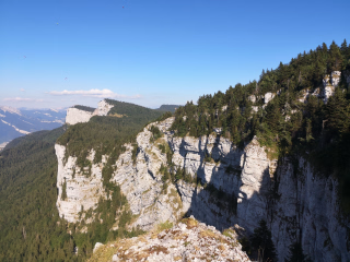
A climb through the forest followed by a wooded ridge leads to the alpine pastures of Charmant Som (1670 m). The presence of herds of magnificent Tarine cows makes it a place of peace and tranquility. The contrast is all the more striking as the descent takes place on the limestone slabs of the Charmant Som. This route offers superb views over the St. Pierre de Chartreuse valley, the end of your stage. This commune is one of the most wooded in France, and forestry is a major industry here.
Distances - Elevation Gain - Walking Time - Technical Skills
18 km, +650m / -1090m, 6 hours of walking
Day 2 -
From Saint Pierre de Chartreuse to La Scia
- Activity Hiking
- Duration of the activity 5h
- Distance 12 km
- Positive elevation gain 850 m
- Negative elevation 180 m
- Maximum altitude 1650 m
- Accommodation Cottage
- Breakfast included
- Lunch not included
- Dinner included
The day revolves around the ascent of an iconic peak in the massif where the St. Pierre ski resort has been located since the 1960s. You'll reach a trail through the forest, a balcony path overlooking the Guiers Mort valley, then the Crêt de la Neige ridge, and finally the summit before arriving at the Gîte de la Scia (1650 m), a magnificent viewpoint. The sunset will undoubtedly be one of the magical moments of your stay.
Distances - Elevation Gain - Walking Time - Technical Skills
12 km, +850m / -180m, 5 hours of walking
Day 3 -
From La Scia to the Circus of Saint Même
- Activity Hiking
- Duration of the activity 6h30
- Distance 16 km
- Positive elevation gain 520 m
- Negative elevation 970 m
- Maximum altitude 859 m
- Accommodation Hostel
- Breakfast included
- Lunch not included
- Dinner included
This is the wildest stage of the week as it takes place in the heart of the Hauts de Chartreuse Nature Reserve. Your only climb takes you to the Col de Bellefond (1902 m), from where you can discover the entire High Plateaux, from the Dent de Crolles to the Granier.
You then cross the isolated alpine pasture of Aulp du Seuil and reach the Habert de la Dame (habert = sheepfold). The descent through the forest crosses the famous Cirque de St Même (859 m) where you stop for the night.
Distances - Elevation Gain - Walking Time - Technical Skills
16 km, + 520m / - 970m, 6h30 walk
Day 4 -
The waterfalls of the Cirque de Saint Même, then a stop in Saint Pierre d'Entremont
- Activity Hiking
- Duration of the activity 5h30
- Distance 14 km
- Positive elevation gain 800 m
- Negative elevation 800 m
- Maximum altitude 650 m
- Accommodation Cottage
- Breakfast included
- Lunch not included
- Dinner included
The Guiers Vif springs forth from the heart of the mountain in the middle of the Cirque. This river divides St. Pierre d'Entremont into two villages, one in Isère, the other in Savoie. Indeed, it marks the old border that separated France from Savoie more than 150 years ago. Your wild route allows you to continue traversing the high plateaus of the Chartreuse Mountains, encountering the chamois and ibex of the Chartreuse massif. A direct descent from the Pas de l'Alpette leads to the renowned Gîte de la Ferme de l'Ours (Bear Farm Lodge).
Distances - Elevation Gain - Walking Time - Technical Skills
14 km, + 800m / - 800m, 5h 30 walk
Day 5 -
From Entremont le Vieux to the Col du Granier, transfer to Chambéry by bus
- Activity Hiking
- Duration of the activity 4h
- Distance 10 km
- Positive elevation gain 600 m
- Negative elevation 500 m
- Maximum altitude 1071 m
- Breakfast included
- Lunch not included
- Dinner not included
From your accommodation in the natural cirque of La Plagne, follow the GR trail to Les Granges de Joigny. A pleasant climb through the forest leads to the Pointe de la Gorgeat and the summit of Joigny, where a final panoramic view of the entire Chartreuse mountain range awaits. The loop ends at the Col du Granier, where you can take the SO4 bus to Chambéry, which stops at the bus station just a short walk from the SNCF train station.
If you came by car you can take a TER train back to Grenoble to return to the starting point.
Distances - Elevation Gain - Walking Time - Technical Skills
10 km, + 600m / - 500m, 4 hours of walking
Day 6
Note
The times were calculated based on a pace of 300 meters of elevation gain per hour uphill, 500 meters of elevation loss per hour downhill, and 4 km per hour on flat terrain, in order to allow for a comparison of the different hikes on the same basis. They only include actual walking time; all meal breaks, rest stops, or periods of quiet contemplation must be added.
We may need to modify your itinerary if the planned accommodations are unavailable during your travel dates. The alternative accommodations offered will be of a similar category and their location will have minimal impact on your route. Rest assured, these changes are always made in your best interest, for your safety and comfort!
All other journeys are made on foot.
The luggage is transported daily by the agency's logistics team.
It is imperative that the baggage weight (1 per person) is respected with a maximum of 10 kilos per person.
From 2 people.
Accommodation
Access
WELCOME :
Day 1: In Grenoble in the morning (bus line No. 62, stop Musée de Grenoble) towards Le Sappey en Chartreuse to start your stay.
Arrival stop: Sappey-en-Chartreuse Place. We recommend departing from Grenoble around 12:00.
By train: Grenoble TGV station: Timetables available from SNCF at 36 35 or www.oui.sncf.
By car: Grenoble Directions: www.viamichelin.fr ( You can park your vehicle in one of the car parks in Grenoble).
DISPERSION:
Day 06 in Chambéry.
Accommodation before or after the hike: If you arrive the day before or leave the day after, we can book an extra night for you.
By train: Chambéry Challes Les Eaux station: Timetables available from SNCF at 36 35 or www.oui.sncf.
By car: After taking the S04 bus from the Col du Granier at the end of the day, you can continue to the Chambéry bus station. Timetable and directions: https://www.laregionvoustransporte.fr/media/1007/download?inline=inline
Go to the starting point
Grenoble TGV station
Timetables available from SNCF at 36 35 or www.oui.sncf.
Grenoble
Route: www.viamichelin.fr
You can park your vehicle in one of Grenoble's car parks
Price details
The price includes
- Organization costs.
- Food and accommodation on a half-board basis.
- The provision of a complete hiking file.
- The GPS application
- luggage carrying
The price does not include
- Lunchtime meals
- Wine during meals.
- Drinks and personal expenses.
- Entrance to the Cave Bear Museum.
- Entrance fees to the various tourist sites
- Personal equipment.
- The journeys to and from the reception location.
- Line bus tickets to be purchased on the buses (approximately 2 euros per person for each journey)
- The different types of insurance: Cancellation and/or Search and rescue costs - Assistance - Repatriation - Interruption of stay.
- Everything that is not listed under "The price includes".
Options
- Picnic : CHF73.18 / person
- Flex fare and insurance
Practical information
Specific formalities
Specifics
During the hike, you must have the following documents in your possession:
- Valid identity card or passport.
- Your travel insurance leaflet received upon registration (if you purchased the insurance we offer) or your personal insurance (contract number + telephone number).
- Health insurance card.
For security reasons, we will ask for the mobile phone number you have with you during the hike.
Equipment
Equipment provided on site
Before your departure, you will receive a complete information pack containing everything you need for your hike. This pack includes:
- A hiking logbook written by us
- The roadmap with the list of accommodations, as well as all additional information.
Equipment to bring
- 1 backpack of 35/40 litres with a flexible frame, equipped with a waist belt.
- A large plastic bag to protect the inside of the backpack.
- 1 water bottle (1.5 liters minimum).
- A pair of poles is recommended.
Attention: Remember that you will be carrying your luggage throughout the week, prepare your equipment accordingly!
Clothing to bring
The ideal list: (to be adapted according to the hike and the season)
- 1 sun hat or cap.
- 1 fleece fur jacket.
- 1 windproof, waterproof and breathable Gore-Tex type jacket with hood.
- 1 rain cape or a sleeping bag cover if you own the jacket above.
- 1 loose trekking pants.
- 1 pair of shorts or bermudas.
- Walking socks.
- 1 pair of high-top hiking boots with good ankle support and waterproof soles (Vibram type). Remember to test new shoes and those that haven't been used for a long time beforehand.
Personal pharmacy:
- A tick remover.
- Your usual medications.
- Elastic adhesive strip, Elastoplast type, 8 cm wide.
- Sets of adhesive bandages + disinfectant compresses.
- Double skin (Compeed or SOS blister type).
- 1 pair of tweezers.
- 1 survival blanket