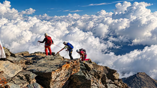
The Matterhorn tour by mountaineering
In summary
-
Sports
-
Duration6 days
-
LevelExpert
-
DestinationValais / Swiss
-
AgeFrom 18 - 70 years
-
CO₂-Emissions32.75 kg CO2
-
Type of stayIn a group
In a few words
Whether you're a passionate mountaineer or simply seeking a major sporting challenge, embark on an unforgettable trek around the Matterhorn (4,478 m), one of the world's most iconic peaks. This mountaineering trek promises pushing your limits, escaping the everyday, experiencing intense emotions, and breathtaking panoramas. Immerse yourself in the heart of the Alps , between majestic glaciers , sharp ridges , deep valleys , and traditional villages , getting up close to the legendary summits in a wild and pristine natural setting. Experience total immersion, surrounded by landscapes of striking beauty. Each stage of your journey will bring you closer to the very essence of the mountains, offering a unique and memorable experience. Whether you're a thrill-seeker or simply looking for tranquility, this trip is designed to offer you the very best of the Alps . Enjoy the serenity of the valleys and the grandeur of the glaciers to recharge and push your limits. The Matterhorn awaits you for an adventure that will forever be etched in your memory.
The highlights
-
A route around one of the most spectacular peaks in the Alps, the Matterhorn
-
A unique mountaineering program
-
Majestic glaciers, verdant alpine pastures and high mountain passes
Photos


Sport
Level
Mountaineering
In figures
Mountaineering
- Average duration/day: 6h30
- Average distance/day: 15 km
- Average daily elevation gain: 1050 m
- Average daily descent: 1026 m
- Maximum altitude: 3710 m
- Exposed Passages: Yes
Management
For up to 4 participants, the group is supervised by a high mountain guide.
Then, with between 5 and 8 participants, the group is supervised by a high mountain guide and a mountain leader.
Program
-
Zermatt - Zmutt Valley
- Activity Mountaineering
- Duration of the activity 4h30
- Distance 13 km
- Positive elevation gain 1100 m
- Negative elevation 5 m
- Maximum altitude 2696 m
- Accommodation Refuge
- Breakfast not included
- Lunch not included
- Dinner included
Meet in Zermatt at 8:30 am to begin your adventure. You'll meet your guide , who will present the program and give you a full briefing before departure. The route starts with a gentle climb, crossing alpine meadows and sparse forests, with snow-capped peaks as a backdrop. Following the Zmutt Valley , you'll discover picturesque hamlets and waterfalls formed by glacial meltwater. The landscape becomes wilder as you ascend, offering breathtaking views of the Zmutt Glacier and the Matterhorn 's walls , which seem to draw closer. At the end of the day, you'll arrive at a mountain hut where you'll spend the night. In a cozy atmosphere, it's the perfect opportunity to connect with other enthusiasts over a delicious meal, with a view of the majestic peaks .
Day 1 -
Tête Blanche (3710 m)
- Activity Mountaineering
- Duration of the activity 6h30
- Distance 13 km
- Positive elevation gain 1400 m
- Negative elevation 750 m
- Maximum altitude 3710 m
- Exposed passages Yes
- Accommodation Refuge
- Breakfast included
- Lunch included
- Dinner included
After a restful night , we begin our day in the heart of the Alps . Our route gradually leads us towards the Tiefmatten Glacier , revealing a wild , mineral landscape . The ascent to the Tête Blanche at 3,710 meters requires endurance and concentration , as we traverse crevassed glaciers with the aid of crampons and ropes . At the summit, the panorama is breathtaking, offering views of the Matterhorn , the Dent d'Hérens , and the Valais peaks .
The descent to the Bertol Hut at 3,311 m is equally memorable . We traverse the Mont Miné Glacier , alternating between glacial expanses and more technical sections . The final approach to the refuge is spectacular , with a steep climb followed by metal ladders fixed to the rock, adding a touch of adrenaline . Perched on a rocky promontory , the hut offers exceptional panoramic views of the surrounding glaciers , providing a strategic rest stop for the rest of our alpine adventure .
Day 2 -
Pointes d'Oren (3532 m)
- Activity Mountaineering
- Duration of the activity 6h30
- Distance 14 km
- Positive elevation gain 1100 m
- Negative elevation 1500 m
- Maximum altitude 3520 m
- Exposed passages Yes
- Accommodation Refuge
- Breakfast included
- Lunch included
- Dinner included
We begin our alpine adventure by leaving the Bertol Hut. The day starts with a descent onto the Mont Miné Glacier . The route then leads us to the Col de l'Évêque at 3,392 m. In this spectacular glacial setting, roped walking and crampons are essential, as the surfaces can be covered in snow or hard ice. The ascent to the Pointes d'Oren at 3,525 m requires considerable effort. Each step is rewarded with breathtaking views of the Dent d'Hérens , the Mont Blanc massif , and the vast glaciers that stretch majestically across the Alps. We begin our descent via the Oren Glacier . The landscape is composed of shimmering snowfields and rocky moraines . This panoramic traverse leads us to the Rifugio Nacamuli , located at 2,783 m in Italy. This welcoming refuge offers a comfortable setting after a day full of discoveries.
Day 3 -
Lake di place (2080 m)
- Activity Mountaineering
- Duration of the activity 5h30
- Distance 12 km
- Positive elevation gain 1100 m
- Negative elevation 1000 m
- Maximum altitude 3082 m
- Accommodation Refuge
- Breakfast included
- Lunch included
- Dinner included
From the very first steps leaving the Rifugio Nacamuli , perched at 2,783 meters , we enter a raw world of rock and ice . The route begins with a technical section through scree and rocky slopes , demanding balance and concentration. As we descend, the terrain gradually softens, and the scree gives way to vast alpine pastures crisscrossed by streams fed by glacial meltwater. These landscapes are dotted with ancient moraines , testaments to a rich geological history.
The climb to the Valcornière pass at 3,067 m is more demanding. As the altitude increases, the vegetation thins out, giving way to a stark, rocky landscape sometimes covered in snow patches . The last few meters before the pass are steep and unstable, requiring good footing on rough terrain. Once at the summit, the view offers sharp ridges and a striking silence , with sweeping vistas of the valley below. The day ends with a gradual descent to our next refuge , nestled in a haven of unspoiled nature.
Day 4 -
Breuil-Cervinia (2004 m)
- Activity Mountaineering
- Duration of the activity 8h
- Distance 23 km
- Positive elevation gain 1600 m
- Negative elevation 1200 m
- Maximum altitude 3319 m
- Exposed passages Yes
- Accommodation Refuge
- Breakfast included
- Lunch included
- Dinner included
The day begins with a descent to the Finestra di Cignana at 2,448 m . The route is sometimes technical , alternating between rocky terrain and steep slopes. The trail demands attention and agility. As we approach the pass, the terrain eases, offering impressive views over the Cignana Valley. We continue our ascent towards the heights of the Plateau Rosa and the Théodule Glacier. As we climb, spectacular views of the Matterhorn and the Valais peaks unfold. The terrain remains challenging with its unstable rocks and persistent snowfields, adding a technical dimension to the adventure. Reaching the Rifugio Teodulo at 3,317 m marks the entry into a high-altitude world. Here, the eternal snows meet the tracks of mountaineering pioneers. Located on the Haute Route between Chamonix and Zermatt, this iconic refuge offers a well-deserved break in a striking setting , on the border between Italy and Switzerland.
Day 5 -
Col du Théodule (3317 m)
- Activity Mountaineering
- Duration of the activity 7h
- Distance 13 km
- Negative elevation 1700 m
- Maximum altitude 3324 m
- Breakfast included
- Lunch included
- Dinner not included
This final day of trekking begins at the refuge at 3,317 m. We cross the Théodule Glacier , surrounded by pristine landscapes. The Matterhorn and the peaks of the Swiss Alps rise majestically. Descending, we reach the Trockener Steg at 2,939 m, where ice meets rock in a striking contrast. The views of Monte Rosa and the Breithorn are breathtaking, offering a complete immersion in the fascinating world of the high mountains.
After the Trockener Steg , the trail becomes more accessible and winds through an increasingly verdant landscape. We follow the Matterhorn Glacier Trail , crossing alpine meadows , ancient moraines , and shimmering little lakes . The peaks that have accompanied us throughout the hike are reflected in these tranquil waters. Arriving in Zermatt at 1,608 meters marks the end of this alpine adventure. We gradually return to civilization in the lively atmosphere of this legendary resort, always under the watchful gaze of the Matterhorn .
Day 6
Accommodation
Access
Go to the starting point
You can easily reach Zermatt by train (we recommend it for this trek, to limit parking costs in Switzerland and facilitate the return).
Price details
The price includes
- The supervision of the UIAGM high mountain guide
- Half-board
- Accommodation in mountain huts or shared dormitories
- Transportation during the stay
The price does not include
- Lunch on Day 1
- Drinks
- Personal expenses
- Tips
Options
- Flex fare and insurance
Practical information
Specific formalities
Specifics
Before your departure, check with the embassy or consulate regarding the entry and stay requirements for your destination country. You can also find this information on the France Diplomatie website ( https://www.diplomatie.gouv.fr/fr/dossiers-pays/ ).
In the case of flights with stopovers operated by different airlines, also check the entry requirements of the countries you are transiting through.
It is your responsibility to ensure you are in compliance, particularly regarding the validity of your identity documents (for example, some countries require your passport to be valid for at least six months after your return) , visa requirements, necessary vaccinations, and health recommendations. And don't forget to consider any customs restrictions and other potential requirements of your destination or transit country.
ℹ️ Information may change up to the departure date, remember to regularly check official websites.
Equipment
Equipment to bring
- Mountaineering boots ( Gore-Tex type and crampon-compatible )
- Cleats
- 1 ice axe
- Harness
- 1 mountaineering helmet
- 1 lightweight sleeping bag liner for the shelter
- 1 backpack of 40/50L
- 2 walking sticks ( telescopic )
- 1 rain cover for the bag
- 2L water bottle or reusable water container
- Sunscreen
- 1 pair of sunglasses ( category 3 )
- 1 lightweight headlamp
- Snacks
- Cash
- Your identity card
Clothing to bring
- 1 cap or hat
- 1 beanie
- 1 ski mask
- 1 waterproof overtrousers
- 1 buff or neck warmer
- 2 jackets ( GoreTex type )
- 2 pairs of thick gloves
- 1 small down jacket
- 2 sweaters ( one light and one warmer )
- technical t-shirts
- 2 to 4 pairs of socks
- 1 pair of mountain trousers
- 1 pair of tights
- 1 short
- 1 waterproof bag to keep spare clothes dry
- Spare clothes for the shelter
- 1 pair of hiking boots ( with Vibram-type soles )