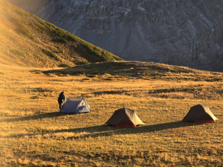
4-day trek in the heart of the Écrins National Park
In summary
-
Sports
-
Duration4 days
-
LevelIntermediate
-
DestinationÉcrins Massif / Hautes-Alpes
-
AgeFrom 18 - 90 years
-
CO₂-Emissions21.05 kg CO2
-
Type of stayIndependent traveler
In a few words
Immerse yourself in the heart of the Écrins National Park on a 4-day trek through pristine and spectacular nature. Starting from Le Monêtier-les-Bains , you'll follow a section of the GR54 , traversing the iconic trails of the Hautes-Alpes . Between welcoming mountain huts and authentic guesthouses , this multi-day trek will lead you to discover hidden valleys , high mountain passes , and alpine plateaus where silence and the raw beauty of the mountains reign supreme.
Designed for hikers seeking an accessible challenge , this trip offers a gradual immersion into the wild, mineral world of the Écrins. You'll cross flowery alpine meadows , walk alongside crystal-clear streams , and spend a night at the Refuge de l'Alpe de Villar-d'Arène , nestled at the foot of shimmering glaciers .
Each stage reveals a new facet of the mountain range: changing light , discreet wildlife , and breathtaking panoramas accompany your steps. This journey combines adventure in the heart of nature with simple comfort , in an authentic setting where you reconnect with what truly matters.
The highlights
-
Trekking on the legendary GR54 in the Écrins National Park
-
Nights at the foot of glaciers and breathtaking alpine landscapes
-
Authentic mountain huts and guesthouses in the heart of the wild Hautes-Alpes
Photos


Sport
Level
Hiking / Trekking
The expert's opinion
Enjoy a fully independent stay: you will have access to an emergency number, reachable only between 9am and 7pm.
In figures
Trekking
- Average duration/day: 4h30
- Average distance/day: 12 km
- Average daily elevation gain: 535 m
- Average daily descent: 648 m
Management
You will receive access to our trekking app, which serves as a complete digital travel guide for the Tour des Écrins. Inside, you will find everything you need for your trek: route descriptions, hiking maps, navigation support, payment information, and all the key details specific to your trip.
Our trekking app also includes built-in navigation assistance. With GPS-based maps and offline access, you can confidently follow the trail and stay on track even without a mobile signal.
Program
-
Le Monêtier-les-Bains - Refuge de l'Alpe de Villar-d'Arène
- Activity Trekking
- Duration of the activity 5h20
- Distance 14 km
- Positive elevation gain 880 m
- Negative elevation 280 m
- Accommodation Refuge
- Breakfast not included
- Lunch not included
- Dinner included
Your adventure begins in the charming alpine village of Le Monêtier-les-Bains, nestled among the peaks of the Écrins massif. The trail leads you along forest paths, alpine streams, and flowery meadows as you gradually gain altitude. The higher you climb, the more expansive the views become, with the Casset Glacier shimmering in the distance.
This first stage is a gentle introduction to the Écrins National Park. With approximately 880 meters of elevation gain, the day offers a balanced mix of challenge and beauty. Keep an eye out for marmots and ibex along the ridges as you approach the high alpine zone.
Upon arriving at the Refuge de l'Alpe de Villar-d'Arène, you'll find a warm welcome and hearty mountain fare. Surrounded by meadows and streams, it's the perfect place to relax and enjoy the tranquility of the French Alps.
Day 1 -
Refuge de l'Alpe de Villar-d'Arène - Gîte Auberge Chez Baptiste
- Activity Trekking
- Duration of the activity 5h
- Distance 14 km
- Positive elevation gain 510 m
- Negative elevation 800 m
- Accommodation Cottage
- Breakfast included
- Lunch not included
- Dinner included
Your second day begins at the peaceful Refuge de l'Alpe de Villar-d'Arène, surrounded by open meadows and the distant murmur of meltwater streams. From the very first steps, you reach the Romanche Valley and descend gently, following a magnificent alpine landscape sculpted by glaciers and rivers. The trail offers sweeping, unobstructed views of the surrounding peaks and the shimmering Arsine lakes, creating a serene and gentle start to the day.
With moderate ascents and long, flowing descents totaling approximately 510 meters of elevation gain and 800 meters of descent, the trail winds past viewpoints overlooking the Arsine Glacier and the waterfalls of the upper Romanche valley. As the route continues, the terrain gradually levels out, and the valley becomes greener and more pastoral, with the Romanche River guiding you through a mix of woods, open meadows, and rocky sections. It's a day to enjoy a steady hike, rich alpine scenery, and plenty of peaceful spots along the water.
The last few kilometers follow a pleasant path along the river leading to the hamlet of Villar-d'Arêne. Here, surrounded by traditional stone houses and the quiet rhythm of village life, you arrive at the Gîte Auberge Chez Baptiste. Expect a warm welcome, hearty home-style cooking, and more.
Day 2 -
Gîte Auberge Chez Baptiste - Refuge du Fay
- Activity Trekking
- Duration of the activity 3h40
- Distance 9 km
- Positive elevation gain 690 m
- Negative elevation 230 m
- Accommodation Refuge
- Breakfast included
- Lunch not included
- Dinner included
The scene begins in the quiet hamlet surrounding the Gîte Auberge Chez Baptiste, and shortly after setting off, you pass through the small village of Le Clot Raffin. Here, the valley opens onto gentle pastures with sweeping alpine views. As soon as you leave the hamlet, the trail begins a steady climb towards the open hills above Villar-d'Arêne. The landscape becomes increasingly wild and expansive, with rolling grassy slopes, scattered streams, and the rugged silhouettes of the Écrins peaks framing the horizon.
The route climbs gradually along natural mountain trails, gaining approximately 690 meters in altitude as it leads you deeper into the highlands. A highlight of the stage is reaching the Emparis Plateau, a vast and magnificent alpine plateau known for its panoramic views and tranquil grassy expanses. This area was shaped by ancient glaciers, creating a mix of open plateaus, rock formations, and panoramic viewpoints overlooking the surrounding valleys and peaks. The hike offers a diverse mix of forest edges, open alpine meadows, and small streams that bring life to the landscape. Towards the end of the stage, the path descends gently before climbing back up to the basin where the Refuge du Fay is located.
Day 3 -
Fay Refuge - Chambon Dam
- Activity Trekking
- Duration of the activity 4h05
- Distance 10 km
- Positive elevation gain 60 m
- Negative elevation 1280 m
- Breakfast included
- Lunch not included
- Dinner not included
The day begins in the tranquility of the alpine basin around the Refuge du Fay, where grassy slopes and scattered rock formations set the tone for your final day. The trail winds across open highlands before gradually descending, offering sweeping views of the deep valley carved by the Romanche River. As you traverse the valley, the landscape alternates between vast meadows, patches of forest, and steep mountain slopes overlooking the Lac du Chambon far below.
A long descent characterizes this final stage, with over 1,200 meters of negative elevation change as the route leads down to Mizoën. The trail alternates between rocky switchbacks, natural paths over the hills, and easier forest tracks, giving each section its own distinct character. With every step down, the landscape opens up to the blue surface of the lake, framed by dramatic ridges and the last high peaks of the Écrins massif. It's a varied and rewarding finish, with numerous viewpoints inviting you to pause and take in the surroundings. The final part of the stage continues down to the shore, eventually reaching the Chambon Dam bus stop.
Day 4
Note
For a fully independent stay, we recommend that you take out the multi-risk insurance offered when you book.
Accommodation

The Refuge de l'Alpe de Villar-d'Arène is a welcoming mountain refuge located in the Écrins National Park, in the heart of a vast alpine pasture dominated by the glacial peaks of La Meije. Accessible via beautiful alpine trails, it offers simple and comfortable accommodation, hearty mountain cuisine, and an authentic atmosphere, ideal for hikers and mountaineers seeking nature and tranquility.

Gîte Auberge Chez Baptiste is a friendly mountain inn located in the hamlet of Chazelet, above La Grave, facing the Meije massif. It offers simple and comfortable accommodation, generous home-style cooking showcasing local produce, and a warm atmosphere. It's a popular stop for hikers thanks to its authentic welcome and spectacular views of the Écrins peaks.

The Refuge du Fay is a mountain refuge located in the Écrins massif, in the heart of a pristine alpine environment. Surrounded by high-altitude meadows, mountain streams, and rocky peaks, it offers simple and welcoming accommodation as well as comforting mountain cuisine. It is a popular stop for hikers thanks to its peaceful setting and authentic atmosphere, far from the hustle and bustle.
Access
The official finish line of the Tour du Parc des Écrins is located near the Chambon Dam on the D1091, between Le Freney-d'Oisans and La Grave. From there, you can easily continue towards Grenoble or Briançon.
By Bus
- ZOU! Line 55 Briançon ↔ Grenoble serves the villages along the D1091 (such as Le Freney d'Oisans , near the dam). Take it towards Le Bourg-d'Oisans or Grenoble.
- From Le Bourg-d'Oisans, you can continue with the Cars Région Isère Line T75 to the Grenoble Bus Station.
Go to the starting point
From Grenoble station, there is line 55 (ZOU!) which serves Le Monêtier-les-Bains.
Price details
The price includes
- The digital travel guide
- Accommodation in mountain huts and dormitories
- Half-board within the accommodations
- Telephone support is available from 9am to 7pm.
The price does not include
- The journey to the place of stay
- Lunches
- Drinks and personal expenses
- Transfers
- The solo supplement (€60)
Options
- Flex fare and insurance
Practical information
Specific formalities
Specifics
Before your departure, check with the embassy or consulate regarding the entry and stay requirements for your destination country. You can also find this information on the France Diplomatie website ( https://www.diplomatie.gouv.fr/fr/dossiers-pays/ ).
In the case of flights with stopovers operated by different airlines, also check the entry requirements of the countries you are transiting through.
It is your responsibility to ensure you are in compliance, particularly regarding the validity of your identity documents (for example, some countries require your passport to be valid for at least six months after your return) , visa requirements, necessary vaccinations, and health recommendations. And don't forget to consider any customs restrictions and other potential requirements of your destination or transit country.
ℹ️ Information may change up to the departure date, remember to regularly check official websites.
Equipment
Equipment provided on site
- Blankets are provided in the mountain refuge and gîte.
Equipment to bring
- A pair of lightweight sandals for the refuge or a pair of sneakers
- A toiletry bag (earplugs recommended)
- A quick-drying bath towel
- For sleeping in mountain huts or guesthouses: a sleeping bag liner
- A small flashlight (with spare batteries)
- Telescopic walking poles (recommended)
- A 1.5L water bottle or hydration pack
- A pocket knife
- An individual plastic container for lunch salads + cutlery and a cup
- Sunscreen cream (skin and lips) + after-sun lotion
- Toilet paper + small garbage bag
- Optional: camera, binoculars…
Warning: the mountains are unpredictable and unpredictable. We've tried to consider all the different weather conditions they can present. This equipment list will help you adapt comfortably to the mountain's moods!
Clothing to bring
- A cap or a hat
- A pair of sunglasses
- A hat or a headband
- T-shirt (carline type, quick-drying material)
- A warm shirt or a thin fleece
- A warm jacket (fleece type)
- A windproof jacket (like a K-Way or Gore-Tex)
- A closed rain cape with sleeves, without snaps, made of polyamide
- Lightweight canvas trousers
- Windproof trousers (like Kway or Gore Tex),
- Shorts or capri pants
- Socks (100% wool: warm, absorbs and wicks away moisture, prevents foot overheating; synthetic fibers: very good resistance, absorbs and wicks away moisture, but be careful if 100% synthetic as it can cause foot overheating; cotton: absorbs moisture but doesn't wick it away well)
- Trekking shoes: they're a hiker's best friend! They must have three qualities: sturdiness, good foot and ankle support (high-tops), and waterproofing.
- Choose shoes with non-slip, cleated soles that are relatively rigid. They need to grip the ground well. Vibram soles have a long-standing reputation; choose them if you have the option.
- A pair of long gaiters
- A pair of gloves
- Spare underwear
- A pair of lightweight canvas trousers and a spare pair of shorts
- Spare socks